
The Battle of Mistick Fort
Overview of Purpose and Results
The “Battle of Mistick Fort Site Identification and Documentation” Implementation Grant archaeologically surveyed and documented two Core Areas identified within the “Battle of Mistick Fort Study Area.”
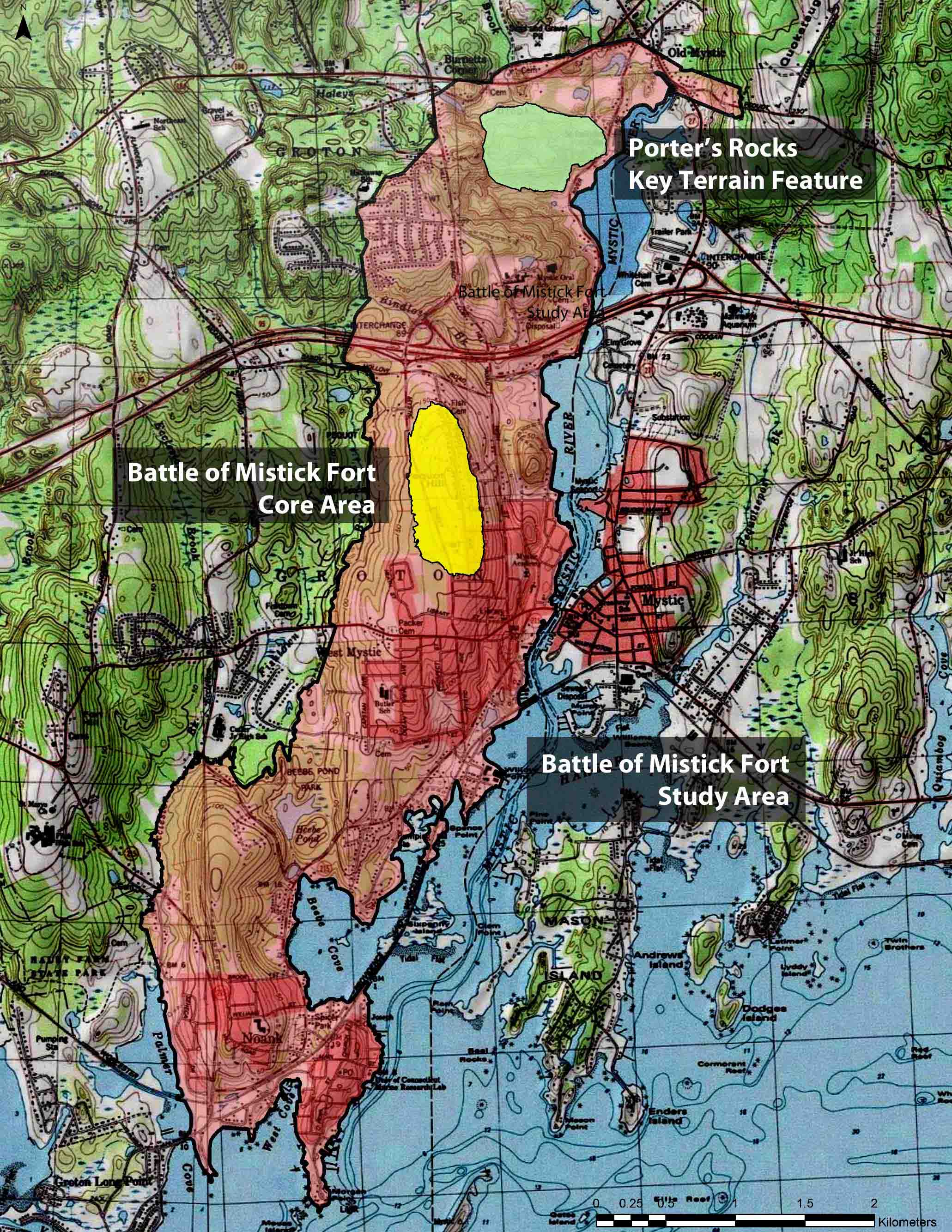
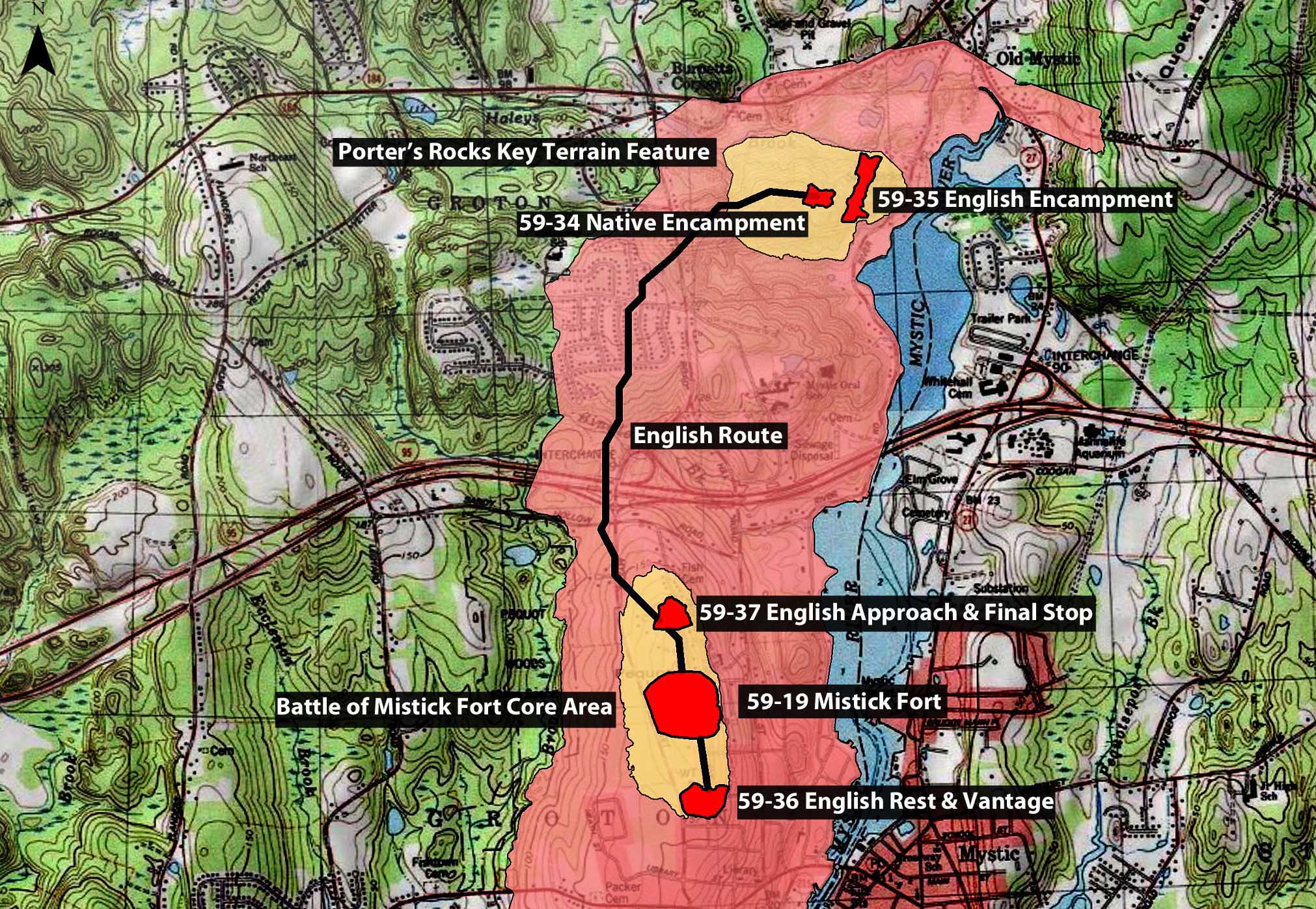
Porter’s Rocks Key Terrain Feature:
Includes Site Number 59-34 (Native Encampment)
and 59-35 (English Encampment).
Battle of Mistick Fort Core Area:
Includes Site Numbers 59-19 (Mistick Fort), 59-37 (English
Approach) and 59-36 (English Rest & Vantage Point).
The “Battle of Mistick Fort Site Identification and Documentation” focused on acquiring baseline data, including: the location of battlefield actions, distribution of artifacts, and subsurface features associated with battles. Boundaries of battlefield sites were based on historical research, archaeological testing (remote sensing and archaeological testing), assessment of integrity, and assessment of eligibility for nomination to the National Register of Historic Places.
This information will be used to develop a long-term preservation plan with the Mashantucket Pequot Tribal Nation, National Park Service, State of Connecticut Historic Preservation Office, Office of the State Archaeologist, National Archaeological Conservancy, Town of Groton, and local preservation and land trusts including the Denison-Pequotsepos Nature Center and the Groton Open Space Association.
The Battle of Mistick Fort Core Area and the Porter’s Rocks Key Terrain Feature were identified as a result of a 2007-2008 National Park Service American Battlefield Protection Program Grant, The Battle of Mistick Fort Documentation Plan.
The Battle of Mistick Fort Core Area includes:
- Site 59-19 (Mistick Fort),
- Site 59-37 (English Approach) and
- Site 59-36 (English Rest & Vantage Point).
The Battle of Mistick Fort is considered a defining moment in American history. On May 26, 1637, a force of approximately 90 English and 100 Native allies (Narragansett, Mohegan, Niantic and Connecticut River Indians) attacked and burned the fortified Pequot village of Mistick Fort, killing over 400 adults and children.
Site 59-19 (Mistick Fort), yielded numerous battle-related artifacts and native domestic material culture from the fortified village. Artifacts uncovered at Mistick Fort not only determined the site boundaries, they also determined the fort’s palisade boundaries. The circular area represents Mistick Fort’s palisade; the placement supported by both excavated cultural material and narrative and primary source document descriptions.
Download and read the Mashantucket Pequot Museum’s
Public Technical Report of the “Battle of Mistick Fort.”

An engraving directed by Captain John Underhill which depicts a birds-eyes view of the Battle of Mistick Fort, May 1637.
